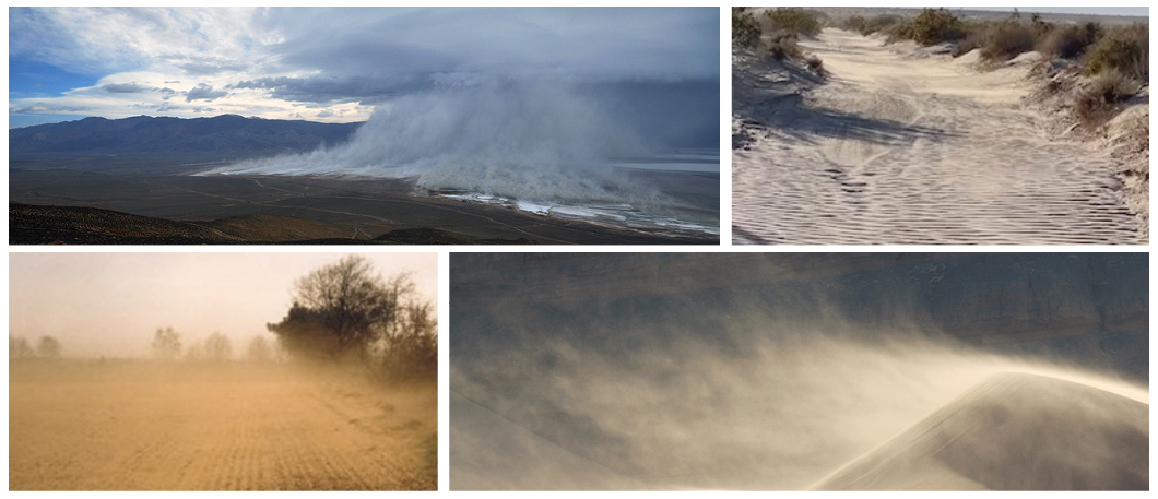
Dust is generated from a variety of landscapes that have sparse vegetation, contain fine sediments, and experience strong winds. This includes large parts of California, including Owen’s Lake, the San Joaquin Valley, and the Salton Sea (Figure 1). Emissions from these and other landscapes have been enhanced by human actions, such as water diversion, agriculture, and off-road vehicle use. In addition, climate-change enhanced drought and wildfires have likely increased dust emissions over levels before the arrival of settlers in the 19th century.

How Dust is Generated
The suspension of soil particles by winds is commonly referred to as dust emission and is an important influence on climate, weather, water resources, ecosystems, and human health. Smaller scale dust events such as dust devils, blowing dust, or haboobs can last minutes to hours and affect areas as small as a few square meters, whereas major dust storms can last for days and be large enough to affect multiple states. Both smaller and larger dust storms can result in millions of dollars in damage as well as damage to human health, including loss of life. Typically, large-scale dust events are initiated by synoptic-scale weather systems, such as a cold front which results in strong turbulent winds driving dust emissions while local scale dust events are commonly the result of smaller circulations, such as convective weather systems, which can produce thunderstorms with downward drafts of air. It is estimated that globally, approximately 2000 millions tonnes of PM10 dust (particulate matter with an aerodynamic diameter < 10 μm) is emitted and transported annually.
Landscapes That Give Rise to Dust Emission
The primary sources of dust emission in California are arid - defined as receiving less than 250 mm of annual precipitation - open landscapes that experience strong winds. Playas, which are oftentimes dry lakebeds, are responsible for the majority of dust emissions from these landscapes. Sand dunes and active sand fields contain much less fine sediment and hence make a smaller contribution, whereas landforms that consist of loose erodible material, such as fluvial (stream erosion) and alluvial (stream deposition) systems contain large amounts of erodible materials and are some of the most productive sources of dust emission.
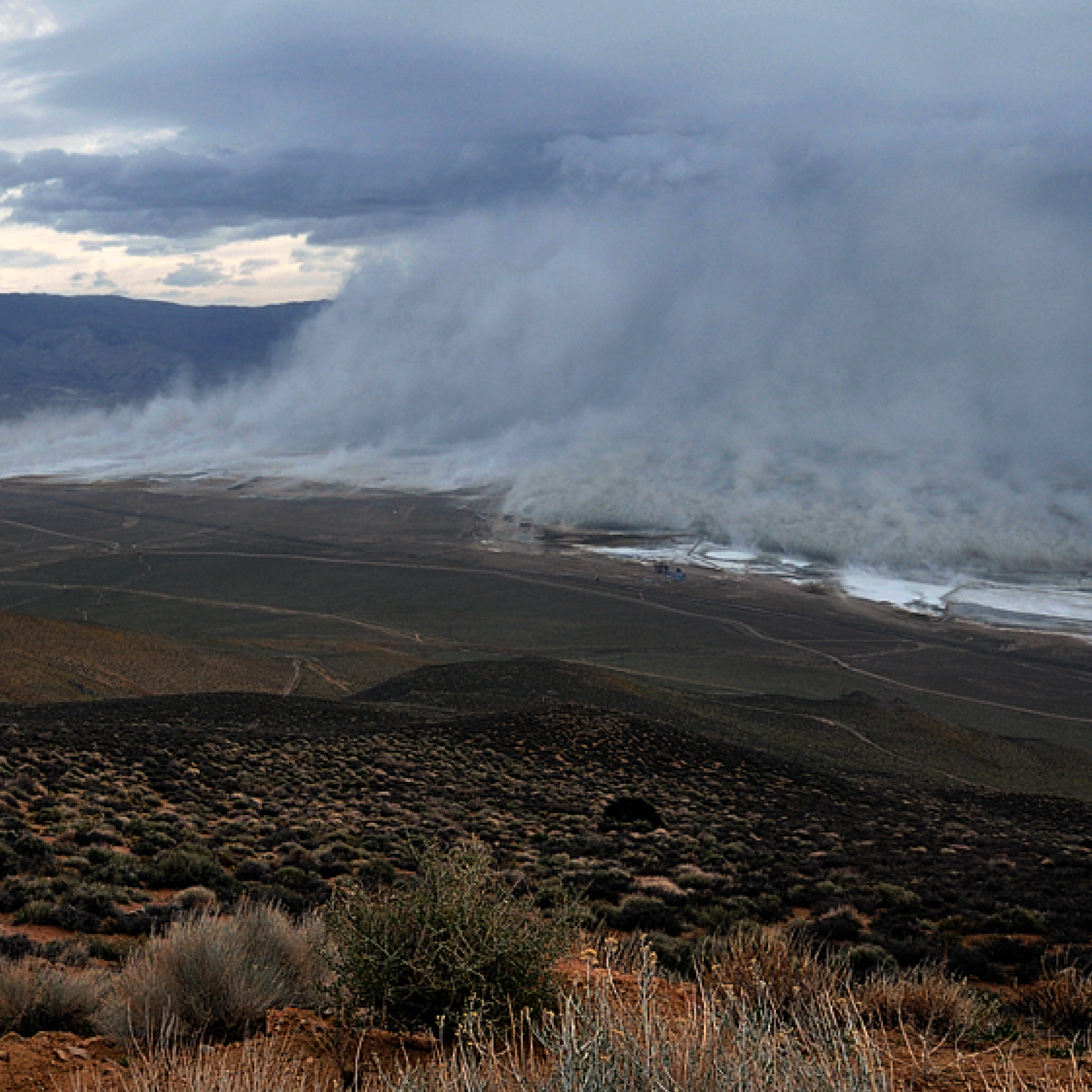
An example of the types of landscapes that give rise to dust emission in California is the Owens Dry Lake, which prior to mitigation efforts was estimated to have generated 72,000 metric tons of PM10 throughout the 2000 – 2001 windy season. There are additional regions in California that, as a result of shifting precipitation patterns, are vulnerable to generating similar events in the years to come, including the Salton Sea and Tulare Lake Basin. Thus it is of critical importance to better understand the mechanisms and drivers of dust emission in California, as well as how wind-driven dust emission in California has changed throughout the last century.
Has Dust in California and the U.S. Southwest changed over time?
Records of dust deposition from ice cores and other sedimentary records indicate that, globally, atmospheric dust has increased by approximately 55 ± 30 % since the 1840’s. In the southwestern U.S. and California, dust emission has likely increased since the arrival of settlers in the 19th century. California has experienced a significant increase in anthropogenic development and activities that began in the 19th century, and lake records in the Rocky Mountains in Colorado show an increase in dust emission that corresponds to accelerated settlement of the region. The resulting dust emission was 500% higher than any other era during the last 5,000 years . These increases in dust emission occurred during a relatively wet period in comparison to the recent “mega drought” that California is facing. This suggests that anthropogenic activities in an increasingly arid environment will result in enhanced dust emission throughout California during the 21st century.
One of the primary drivers of increasing dust emission at the state level has been the general decrease in soil moisture content, which has resulted in drier soils that are more susceptible to wind-driven erosion . Atmospheric circulation patterns (such as the El Niño/La Niña-Southern Oscillation, ENSO, and Pacific Decadal Oscillation, PDO) have also been identified as meteorological controlling factors of dust emission. In addition to local dust emissions, another prominent source of dust to California is cross-Pacific transport (CPT), where dust from Asia and North Africa is transported across the Pacific ocean and deposited throughout the Pacific coast of the U.S.

Anthropogenic Dust Emissions
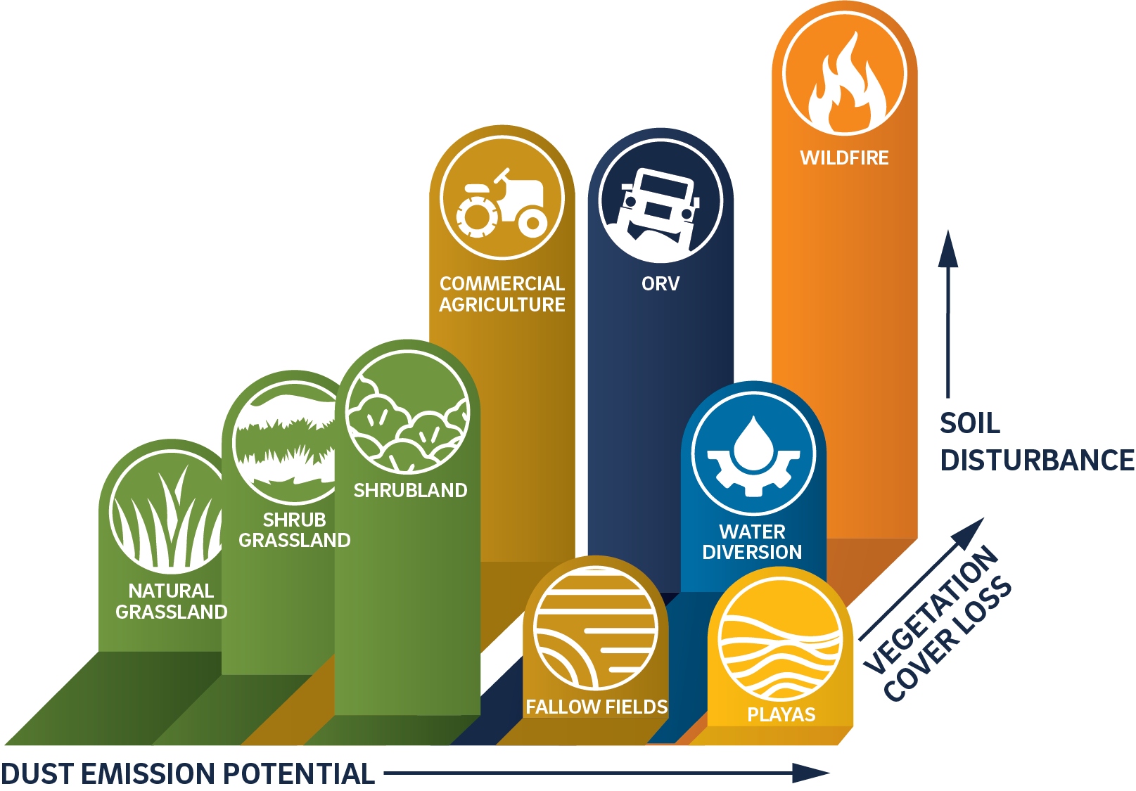
In addition to identifying the natural sources of dust emission, it is also of critical importance to ascertain and quantify California’s anthropogenic sources of dust emission; some of which could be reduced or mitigated by changes in policies or practices. In general there are two categories of anthropogenic dust emissions; emission from changes in land cover or land use, and emission that is the result of changes to the climate.
Environmental Engineering
One of the primary anthropogenic drivers of dust emission within California is the diversion of flowing water for agricultural and urban development. This has occurred throughout the state at various locations, such as the Owens Valley-Mono Basin (Owens Valley) , Salton Sea, and Tulare Lake. There has been some initial success during the 21st century in reducing dust emission from these regions, although more recent data indicates that dust emission in the Owens Valley is increasing again as a result of the ongoing and increasing aridity of the region.
Arid landscapes, which are the primary dust emitting regions within the state of California, have also started to experience shifting vegetation patterns due to anthropogenic activities such as the development of infrastructure and agriculture, as well as due to the effects of climate change. There are projections that many of California’s deserts, such as the Mojave, are expected to experience an expansion of scattered woody vegetation (shrubs) at the expense of relatively more continuous grass cover, as the climate continues to warm and precipitation becomes increasingly irregular. As these landscapes become increasingly dominated by woody vegetation, there is a corresponding increase in soil surface heterogeneity. This causes an overall increase in the amount of bare soil that is susceptible to wind events and is expected to result in an overall increase in dust emission throughout these regions.
Agriculture
Agricultural fields are a prominent source of anthropogenic dust that has ecological implications for the environment as well as serious medical consequences for local community members. California is home to the San Joaquin Valley, where over 340,000 people work in the agriculture industry, which produces more than $24 billion in annual revenue. However, the San Joaquin Valley is also home to the most polluted air within the United States, which results in excessive rates of respiratory and cardiovascular diseases (such as asthma, atherosclerosis, myocardial infarction, and various forms of cancer). In a 2014 – 2015 survey of community members within the San Joaquin Valley, 91.8% of respondents were concerned with the air quality there. Dust emission is likely to get worse as the region continues to become increasingly arid and the amount of water available for irrigation decreases. The San Joaquin Valley is also facing the possibility of fallowing approximately 900,000 acres (17.7% of the San Joaquin Valley’s agricultural fields) of cropland by 2040 as a result of shifting climatic conditions and the Sustainable Groundwater Management Act, which will likely increase the amount of dust emitted from agricultural fields. These changes in land use and land cover have resulted in the creation of novel dust sources in California that previously were less susceptible to aeolian processes.
The activities surrounding the maintenance and development of agricultural fields is also a critical source of dust emission in arid and semi-arid environments such as California. Arid agricultural soils can emit up to 6 times more PM10 than if left undisturbed in their natural state, due to the disturbances that are necessary for the maintenance of these agricultural fields. These activities can have significant implications for the health of the agricultural workers that are maintaining these fields and to the members of the surrounding communities.
Vehicles
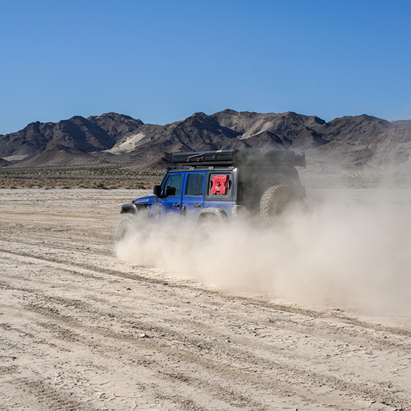
In the United States, off-road vehicle (ORV) driving is one of the fastest growing recreational activities, and California is the largest ORV market in the country, accounting for 10% of sales nationally. ORV driving results in extensive damage to the landscape (soil, flora, and fauna), and is one of the most destructive uses of land. The damage from ORVs can require decades without disturbance to recover, and that is if recovery is even possible. The ORV market is projected to see sustained annual growth of almost 6%, which will likely result in increasing ORV activity as well as an increase in the amount of soil susceptible to aeolian dust emission.
In addition, ORVs are capable of producing large amounts of dust, particularly at the local scale where it can pose a significant hazard to human health (Candeias et al., 2020; McKenna Neuman et al., 2009). Research has shown the dust concentrations around an ORV can be up to 10,000 times (up to 1,000,000 μg m-3) higher than ambient dust levels. The soil particles that ORVs emit will frequently contain components that would otherwise remain attached to the soil surface and not become suspended, even during strong wind events (Ploughe and Fraser, 2022). This can be particularly dangerous if the soil is contaminated with chemical or organic compounds (Goossens et al., 2012). In conjunction with California’s increasing aridity, ORVs have the potential to accelerate the degradation of important ecosystems and thereby drive increased dust emissions.

Wildfire
California’s climate is becoming increasingly vulnerable to the effects of climate change, and one of the consequences has been an intensification in both the frequency and intensity of wildfires. Over the last four decades, over 8.5 million hectares have burned throughout California, and these fires have been increasing in size and severity over time. In addition to the immediate ecological impacts and human cost, there is a significant and immediate effect on air quality and dust emission as a result of wildfires.
Wildfires leave a completely altered and disturbed landscape with reduced vegetation. Since vegetation acts as a windbreak and covers the surface, wildfires leave the landscape vulnerable to aeolian and fluvial erosion. Wildfires also have the potential to modify both the physical and chemical properties of soil, which can induce soil-water repellency and decrease the threshold wind velocity needed for wind driven dust emission to occur. As such, there is a significant increase in wind driven dust emission following wildfires, suggesting an increase in dust emission as climate change continues to increase fire risk.
Drought
Since the beginning of the 21st century, California has experienced unprecedented drought conditions that have resulted in the driest period (2000–2021) the state has experienced over the last 1200 years. Current forecasts are that this drying trend will continue throughout the state and the southwest as a whole. This increase in overall aridity as well as the corresponding decrease in soil moisture has already resulted in a significant (240%) increase in aeolian activity over the last 30 years throughout the southwestern U.S. As the region continues to experience increasing levels of aridity, there will likely be corresponding increases in aeolian activity and wind driven dust emission. Since the beginning of the 21st century, California has experienced unprecedented drought conditions that have resulted in the driest period (2000–2021) the state has experienced over the last 1200 years. Current forecasts are that this drying trend will continue throughout the state and the southwest as a whole. This increase in overall aridity as well as the corresponding decrease in soil moisture has already resulted in a significant (240%) increase in aeolian activity over the last 30 years throughout the southwestern U.S.. As the region continues to experience increasing levels of aridity, there will likely be corresponding increases in aeolian activity and wind driven dust emission.

Dryland vegetation-dust interactions
Deserts exhibit a distinctive patchy landscape with a mosaic of vegetated areas interspersed with bare ground across various spatial scales, often tied to specific microtopographic features. This patchiness reflects a close interplay between vegetation distribution and surface transport processes of water, water-borne sediment, and wind-blown soil and dust, highlighting important interactions between geomorphic processes and dryland vegetation. Thus, understanding the complex interactions between wind erosion, vegetation dynamics, and soil processes is crucial for effective management and conservation of arid and semi-arid ecosystems, as well as addressing desertification challenges and predicting changes in dust sources and dust emission rates.
In grasslands, bare and grassy patches alternate over small distances, especially on sloping terrain, creating a stepped topography. Similarly, in shrublands patchiness extends over a few meters, with bare swales and vegetation-covered mounds. Larger shrubs and trees contribute to a landscape characterized by alternating concave-upward intergroves and flatter groves. In some cases, on sandy soils vegetated patches are associated with more elevated geomorphic features consisting of soil mounds, typically at most 1-2 m tall. Often known as ‘coppice dunes’ or ‘nebkas’, these landforms are induced by the ability of shrubs to trap aeolian sediment and therefore are preferential sites for dust deposition and accumulation. These features can be observed across the arid and semiarid landscapes of California in the south-eastern part of the State.
Bare soil patches play a crucial role in aeolian erosion and dust emission, water erosion rates, and biogeochemical processes. Furthermore, bare soil patches typically form a network of conduits (or “streets”), allowing for the movement of water, soil, and dust, via wind or waterborne processes. Studies suggest that changes in functional and structural connectivity due to rapid vegetation shifts can lead to dryland degradation, with accelerated erosion and dust emission rates. Such rapid changes in vegetation composition have historically occurred as an effect of exotic grass invasions or native shrub encroachment induced by climatic variations or human activities. Shrub encroachment is occurring worldwide, including the coastal and inland arid grasslands of California, and has been related to global drivers (such as climate warming, nitrogen deposition, increased atmospheric CO2 concentration) as well as local land use practices (e.g. grazing and fire management). Indeed, woody plant encroachments in drylands typically occur with the replacement of a relatively continuous grass cover with scattered shrub vegetation bordered by bare soil patches. The larger fraction of bare soil typically observed in shrub encroached landscapes (with respect to the grasslands they have replaced) allows for an increase in dust emissions and wind erosion, a phenomenon often known as “land degradation” because of the loss of nutrient-rich fine soil particles. The dependence of dust emissions on vegetation cover is only incompletely captured by the fraction of ground surface area covered by vegetation because it also strongly depends on patch size, orientation of bare soil “streets” with respect to wind direction, as well as vegetation height.
Both wind and water erosion play crucial roles in maintaining the spatial heterogeneity of vegetation cover and soil resource distribution in arid and semi-arid environments. Particularly, wind erosion can remove nutrient-rich particles from the soil surface, irrespective of relief features and plays a crucial role in the formation and dynamics of patchy distributions of vegetation and soil resources. Indeed, it has been observed that shrub encroachment is associated with the formation of nutrient-rich shrub patches (known as “fertility islands”) bordered by nutrient-poor bare soil areas. The transition from relatively uniform grass cover to a heterogeneous shrub-dominated landscape with fertility islands is driven by wind-borne transport of nutrient rich fine aeolian sediment from bare soil to vegetated patches, where it settles and remains sheltered by vegetation. These dynamics have an inherent positive feedback, whereby bare soils areas become increasingly nutrient depleted, thus impeding vegetation growth therein and rendering them more susceptible to wind erosion, while shrubby patches accumulate and stabilize nutrient rich soil particles.
Enhanced wind erosion leads to the removal of organic carbon and nitrogen from the soil surface, altering soil fertility patterns and reinforcing landscape conditions that are suitable to wind erosion. These dynamics have been well-documented and explained by vegetation removal experiments in Southern New Mexico, where soils saw losses of nitrogen (up to 82% over a decade) and of plant available phosphorus (up to 62%). Other studies highlighted major losses of soil organic carbon, as well as of total soil nitrogen.


